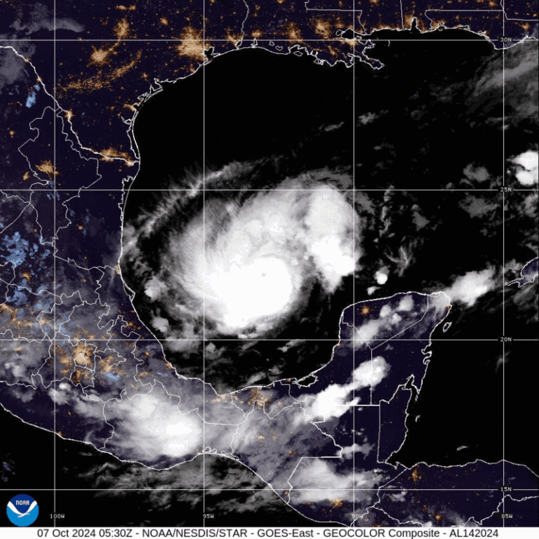
As Hurricane Milton continues to strengthen, the Florida Gulf Coast, including Tampa Bay, is now under a Hurricane Watch and a Storm Surge Watch. With sustained winds of 125 mph and a pressure of 945 mb, the storm is moving east-southeast at 8 mph. Currently located 745 miles southwest of Tampa, Milton poses a serious threat to the region. The National Hurricane Center warns that conditions could deteriorate rapidly, with life-threatening storm surges and hurricane-force winds expected within the next 36 to 48 hours.
Watches and Warnings in Effect
As of 7:00 AM CDT, the following advisories are in place:
- Hurricane Watch: From Chokoloskee to the mouth of the Suwannee River, including Tampa Bay and the Dry Tortugas.
- Storm Surge Watch: Along the Florida Gulf Coast, from Flamingo to Suwannee River, including Tampa Bay and Charlotte Harbor. Storm surges could reach dangerous levels, posing significant risks to low-lying areas.
- Tropical Storm Watch: For the Lower, Middle, and Upper Florida Keys, including Florida Bay, as well as regions north of Suwannee River up to Indian Pass.
These warnings emphasize that preparations should be rushed to completion, as hurricane conditions could hit within 36 hours. A Hurricane Warning is also in effect for parts of Mexico, from Celestun to Rio Lagartos, as Milton affects the Yucatán Peninsula before moving toward Florida.

Milton’s Path and Intensification
Hurricane Milton, currently positioned at 21.8N, 92.2W, continues its path across the Gulf of Mexico after developing near the Yucatán Peninsula. The storm is expected to maintain or increase its strength as it approaches Florida, bringing heavy rains, strong winds, and dangerous storm surges along the Gulf Coast. Evacuations may be issued soon, with residents in affected areas urged to finalize preparations for what could be a catastrophic event.
The government’s advisory specifies that hurricane-force winds and tropical-storm-force winds will make preparations dangerous once they arrive. Coastal residents are particularly urged to prepare for flooding and storm surge, as Milton could potentially cause severe inundation across the region.
Timing and Preparation
With warnings typically issued 36-48 hours before the onset of tropical-storm-force winds, Florida residents in the watch area should complete their preparations immediately. This includes securing properties, gathering supplies, and preparing for potential power outages. Coastal communities, especially those in low-lying areas, should be on alert for evacuation orders, particularly in areas included in the Storm Surge Watch.
Governor Ron DeSantis is expected to issue statements later today regarding evacuation orders and disaster preparations. Florida officials are coordinating with federal agencies to ensure that shelters and emergency services are prepared for the hurricane’s potential landfall.
What to Expect
- Winds: Hurricane Milton’s maximum sustained winds of 125 mph classify it as a Category 3 storm, capable of causing widespread damage to buildings, downing trees, and knocking out power. Gusts are expected to increase further as it approaches the coast.
- Storm Surge: The most life-threatening aspect of Milton is the potential storm surge, which could flood coastal areas and rivers. Areas from Tampa Bay to Charlotte Harbor are particularly at risk.
- Rainfall: Milton is expected to produce heavy rainfall across the Gulf Coast, with flash flooding a serious concern. The storm could dump several inches of rain across Florida, leading to additional flooding, particularly in areas that are still recovering from previous weather events.

