In a concerning weather development, the Met Office has issued an amber weather warning for thunderstorms across parts of eastern and south-eastern England. The warning, which stretches from Eastbourne in Sussex to Cromer in north Norfolk, is in effect from 20:00 BST on Friday evening until 05:00 BST on Saturday morning. With the potential for severe weather conditions, including flash flooding, power cuts, and travel disruptions, the public is being urged to take precautions and stay informed as the stormfront moves across the region.
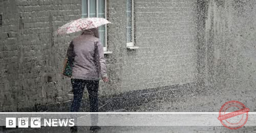
This amber warning has been issued in response to the growing likelihood of intense thunderstorms, which are expected to bring a significant amount of rain, high winds, and frequent lightning strikes. Some areas within the warning zone could see up to 30-50mm of rainfall, with winds gusting in excess of 40-50mph. As a result, flooding of homes and roads is likely, particularly in areas where heavy rainfall leads to flash floods. The Met Office has cautioned that fast-flowing or deep floodwaters are likely, creating dangerous conditions that could put lives at risk.
The timing of this weather event adds to the sense of urgency, as it coincides with what could be the hottest day of the year so far. On Friday, the temperature in areas such as Norwich could reach 30C (86F), possibly making it the hottest day of 2025, surpassing the previous record of 29.3C set in Kew, London, on May 1. The combination of soaring temperatures, rising humidity, and the impending thunderstorms is expected to make for a volatile and hazardous weather scenario.
In light of the amber weather warning, the Met Office is advising those in affected areas to take immediate action to protect themselves and their property. One of the key recommendations is to avoid traveling by road, as the combination of rain, wind, and difficult road conditions could make driving extremely dangerous. For those who must travel, the advice is to drive cautiously, avoid floodwaters, and take extra care when navigating local roads, which may quickly become impassable due to flash floods.
The public is also encouraged to stay indoors as much as possible, particularly during the hours when the thunderstorms are expected to reach their peak intensity. For those who live in areas prone to flooding, securing property and ensuring that drains and gutters are clear will be vital in minimizing potential damage. In addition, the Met Office suggests that people check on vulnerable neighbors and loved ones who may need additional support during this severe weather event, particularly those who may have difficulty accessing food, water, or medical supplies.
As the amber warning for thunderstorms in eastern and south-eastern England remains in effect, yellow warnings for thunderstorms have also been issued for other parts of the UK. These yellow warnings cover regions such as south-west England, Wales, and northern parts of England, where thunderstorms are expected to be severe but more localized. These yellow warnings are set to last throughout Friday and Saturday, with the following times specified:
- South-west England and Wales: Friday from 14:00 to 23:59.
- Eastern and south-eastern England: Friday from 19:00 to Saturday at 06:00.
- Wales, western and northern England, and Scotland: Saturday from 00:00 to 18:00.
As the thunderstorms spread across the UK, it’s clear that the effects of the storm will be felt beyond just the areas covered by the amber warning. The heavy rainfall and intense storms could affect large portions of England, Wales, and Scotland, potentially leading to further disruption of travel services and posing risks to public safety.
Meanwhile, the heat and humidity leading up to the storm have created an oppressive atmosphere, particularly across northern and eastern parts of England. On Friday afternoon, temperatures in these areas are expected to peak, with 30C (86F) possible in places like Norwich, and high twenties to low thirties across East Anglia and south-eastern England. These temperatures are around 7 to 10C above the average for this time of year, which has contributed to the brewing conditions for thunderstorms. As the air becomes increasingly saturated with moisture, the risk of thunderstorms becomes even more pronounced, bringing an end to the unseasonable warmth and signaling a shift toward cooler weather.
In terms of long-term weather outlook, the arrival of these storms will result in a significant drop in temperatures on Saturday. The highs across eastern England will likely be in the low to mid-twenties, while areas further north and west will experience temperatures in the high teens. This sudden temperature change will bring relief from the intense heat but also create a stark contrast to the scorching temperatures of the preceding days. The thunderstorms, while bringing an end to the heatwave, will also contribute to a sudden shift in the region’s weather patterns, leading to a cooler and wetter weekend.
For those living in the affected areas, it is essential to stay informed and prepared as the storm approaches. The Met Office has provided detailed guidance on how to stay safe during a storm, emphasizing the need to stay indoors during intense lightning and rainfall. Those who find themselves caught outside should seek shelter immediately and avoid standing near tall structures or trees, as lightning strikes can be dangerous in open spaces. Additionally, the Met Office advises people to avoid crossing floodwater when driving or walking, as even shallow water can quickly become hazardous.
For travelers, disruptions to train and bus services are expected, particularly in areas where the thunderstorms lead to flooding or poor visibility. Passengers are advised to check with local transit authorities for the latest updates on schedules and potential cancellations. The heavy rain and high winds could cause delays or detours, making travel plans uncertain for many.
While the storms may bring relief from the heat, the potential for flash flooding, strong winds, and travel disruptions underscores the importance of staying vigilant during extreme weather events. Authorities urge the public to follow official advice, stay up to date on weather alerts, and take proactive measures to safeguard their homes and loved ones.
In conclusion, the amber weather warning issued for thunderstorms across parts of eastern and south-eastern England serves as a stark reminder of the unpredictability of the British weather. As the country prepares for potentially severe storms, residents are encouraged to stay informed and take necessary precautions to protect themselves and their property. With intense rain, high winds, and possible flooding on the horizon, it is crucial to remain cautious and prepared as this weather event unfolds.
The post Severe Thunderstorms and Amber Weather Warning Issued for Eastern and South-Eastern England first appeared on Trusted and Verified USA News.