LOUISVILLE, Ky. (WDRB) — From snow and ice to tornadoes and flooding, the Louisville area has been hit with a variety of severe weather just four months into the year.
People around the Louisville area have faced power outages, road closures, school cancellations due to weather-related events in 2025.
“It’s actually been some of the craziest patterns of weather we’ve had in a long time,” said Cameron Harper, who lives in Louisville and visited the Waterfront Park Saturday to see the rising Ohio River.
To start the year, Louisville surpassed 9 inches of snow on Jan. 5, making it the third snowiest calendar day ever recorded in the month of January. It was the snowiest calendar day since Feb. 4, 1998. The snow fall was followed by frigid temperatures.
In February, snow and extremely cold temperatures once again hit Louisville. Roads were also closed due to flooding after heavy rain and winter weather.
The city’s geographic location plays a part in weather residents face, according to University of Louisville professor Scott Gunter.
“It’s been a very busy winter season and into the spring season,” Gunter said.
Gunter is an assistant professor in Geographic and Environmental Sciences, focusing in climatology and meteorology. He said Louisville isn’t necessarily unique in the variety of weather it sees, which can be comparable to Tennessee and Indiana, but the region does get its share of intense weather.
“One of the things that really is unique for us is the overall storm path and orientation of the jet stream,” Gunter said. “Another big aspect that drives our weather is our proximity to the Gulf of Mexico.
“All of these things overlapping, really make Louisville an interesting place to be weather-wise.”
Clay Clavert, who lives in Jeffersonville, called the past few months “a whirlwind” due to the weather.
“I don’t remember it being this wild before,” Clavert said. “You’ve got tornadoes, flooding, you watch the news, at the same time up north you’ve got freezing.”
Thousands of people were left without power and there was extensive damage after severe weather moved through the Louisville area April 2. The National Weather Service confirmed a tornado touched down in Jefferson County, near the Interstate 64/265 interchange.
Gunter said wind hazard stands out as a severe weather element that can produce the most damage for Louisville and Kentucky.
“This area is interesting because a lot of what drives what we measure in terms of wind speed is what is around us,” Gunter said. “Some places you have a lot of hills and trees, the Bluegrass area is flat and there aren’t a whole lot of trees. That combination can allow for some big variability in wind speeds.”
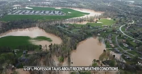
Louisville’s most recent weather event has included damaging winds, tornadoes, heavy rainfall and flooding.
A state of emergency was already declared in Louisville on Thursday after tornado damage and anticipation of the severe flooding that’s on the way. City officials said Friday that it could be a top-10 flooding event in the city’s history.
“The impact of the Ohio River flooding has a lot of impacts, a lot of impacts on people’s daily lives,” Louisville Mayor Craig Greenberg said.
The Ohio River is expected to crest Wednesday at 35.6 feet in the upper pool. That includes the area of the downtown Louisville side of the McAlpine Lock, around 23 feet above typical river levels.
“There are unique aspects of this event, it’s a big deal for this city and for Kentucky given the amount of flash flood warnings, tornado damage that we’ve already seen,” Gunter said. “It’s always hard seeing the impact in the community.”
From colder than normal weeks in the winter to historical levels of rain in the spring, Louisville has faced a gauntlet of weather-related events in 2025.
“We have to be very careful when we differentiate between weather and climate,” Gunter said. “Climate is a long time frame, we want 30 years of data to say this is a trend or difference. A lot of the stuff we experience day-to-day is just weather. It’s random. It’s chaotic.”
For Louisvillians, the severe weather hasn’t been easy to handle in recent months.
“It’s definitely something, weather is going to do what weather wants to do,” Harper said.